Photo by Bob Baikauskas
Lincoln Hills
Photography Club

South Yuba River State Park

The Visitor's Center is on the left as you approach Bridgeport, had several plant identification booklets, an assortment of postcards, a large taxidermied bear, and other animals. It was a pleasant place, well done. Surrounding the visitor's center were a restored 1920's gas station, and an old barn with very old wagons. The small cemetery a hundred yards down the historical roadway had graves of people important when the city of Bridgeport was being developed.
The old covered bridge was closed for renovation. We asked docents why they were wearing SOB signs. Their answer, Save Our Bridge.
Two trails in this park are well known for their diverse display of wildflowers, Buttermilk Bend and Point Defiance Trails.
Covered Bridge at South Yuba River State Park

Pipe Vine Swallowtail on Canyon Dudlea

White Globe Lily

Spider on Blue Dick

Spider on Yarrow

Lacepods

South Yuba River

Blue Eyed Grass

Fence Lizard

Fiddleneck

Pipevine, the larval host to the Pipevine Swallowtail Butterfly
To Get There
The park is 60 miles from SCLH. There are two routes, both about the same distance, and taking about the same time.
(1) Follow Route 65 and Route 70 to Marysville and then turn right on Route 20. You'll come to Penn Valley and a traffic light. Turn left on Pleasant Valley Road. Continue to the park.
(2) Follow I-80 to Auburn and then north on Route 49. Turn left on Route 20 and in Penn Valley, turn right at the light onto Pleasant Valley Road.
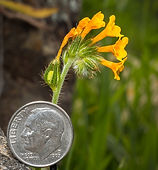
Wildflower
Guide
Trail Map
Bridge
Brochure
Barn
Brochure
Early
Wildflower
Guide
Mid-Season
Wildflower
Guide
Late-Season
Wildflower
Guide